Hike 46 – North Portland Sunday Parkways (Again)

Last July I started this nonsense, not only hiking every single week, but also blogging about it. I made a decision to get healthier, physically and in the mentals. The thing about exercise, it kinda helps you work out the other. You get out of your mind and into your body. It’s the best form of therapy.

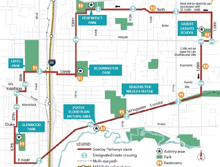
Our first official Sunday together my sister and I walked the 9.5 miles of the North Portland Sunday Parkways. If you scroll down, a loooong way, you will find it. We did it cold. Neither of us had really been exercising at all. It was so hot. We ran out of water. I almost fainted in Subway afterword. It was really really hard.

Well, today I got a chance to come full circle. It was the exact same route. It was hot. I still only brought one thing of water and ran out, but none of that mattered. I did it lickety-split, literally an hour faster. I walked alone this time. My sister had to work. I didn’t tear up when I walked by the dream house that used to be my house and was taken from me. I didn’t yearn for it to be over. I just walked it. It was awesome. One little girl even said, “Mama, we saw that lady last time! I remember her stars!” She was right. I remembered her too. She was a cutie-pie. It was a brilliant walk. I can’t wait for next year!

I got to see the beautiful and wonderful Emily Baumbach. I also got to see her daughter, but she was mostly crying and walking away and not appreciating that her Mom and me were catching up. I get that. Bike crashes are terrible and adult-talk is the most boring thing ever.

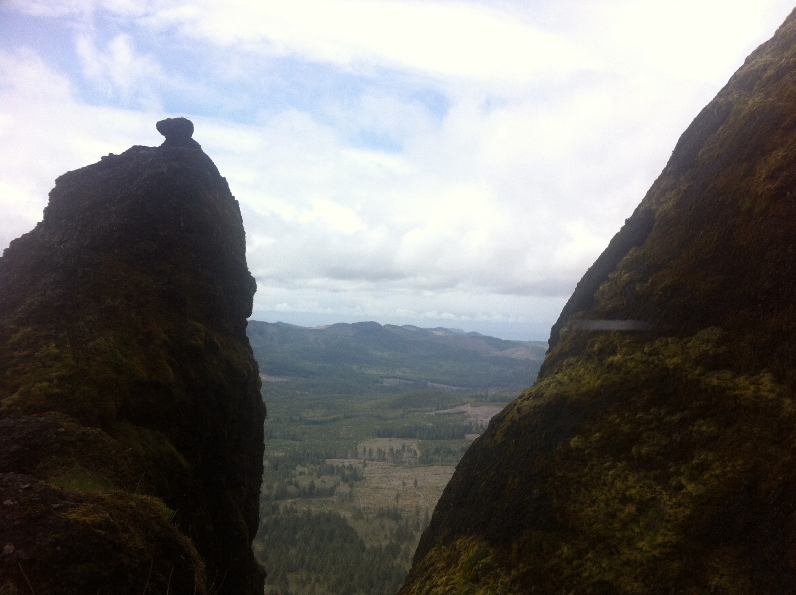
I took a picture of myself after I finished. It’s above. I used to hate having my picture taken, like really a lot. Because of that, I don’t really have any before pictures. I’m okay with that. The after picture is good enough. When my sister and I reach 52 hikes, I will definitely post about how this journey has changed me physically. It’s pretty substantial. But like I hoped, it has also helped me to find myself. I’m the type of person who goes out in the community and walks 9.5 miles surrounded by crazy cyclists just because I want to. Who knew?

For information about Sunday Parkways click here.

Advertisement

Hike 45 – La Jolla

In 2004, my sister and I went to Europe. We had a flight into London and a flight out of London 70 days later. We had a reservation in a London hostel for our first night. We had 60 lb backpacks and we had the cash we had been saving for five years. Beyond that, it was all up in the air.  In the 70 days we went to so many amazing places and met so many amazing people.  Our journeys included: London, Leicester, Liverpool, Edinburgh, Manchester, Amsterdam, Berlin, Prague, Vienna, Trieste, Venice, Brindisi, Corfu, Naples, Rome, Sorrento, Cinque Terre, Nice, Lyon, Paris, Madrid, Barcelona, Valencia, and some more I can’t remember without getting out my journal. When we were in high school, she and I started the “old maid” fund. We are hard to get along with. We assumed we would be naggy, old ladies who lived together some day in the distant future. We contribute to it each month. That is what we used to go to Europe. That is also what we used to go to La Jolla! I went to Vegas with my girls last year. My sister went to Austin to visit in-laws. Beyond that, neither of us have taken a vacation since 2004. What is wrong with us? We obviously need to re-prioritize.

We knew we wanted a beach. We knew we wanted sun. We had a budget and we just made it happen. La Jolla was a fantastic trip and it was worth every penny. You may be asking, why are you putting your beach vacation on your hiking blog? Because, it’s my blog. You’re not the boss of me! We didn’t hike. We had every intention of hiking. There are great hikes in the Torrey Pines State Park. That park is 7 miles away. On our low budget trip to Europe we learned a lot of things and we apply them in our travel today. Never pay for a ride when you can walk. Never pay for a restaurant when you can cook. Never take a guided tour when you can do it yourself for free. We could have walked to the State Park, but it just seemed silly to walk so far for a hike.

We did walk. We took the stairs to our fourth floor room every time. The pool was two flights up. The continental breakfast was one floor up. The beach was all the way across the street and down a hill. We went to the grocery store a mile away at least once a day. We also walked to a gluten free Italian restaurant that was all the way on another beach, 1.5 miles away, and back. See, we exercised. I’d guess we walked about 5 miles each day. We also ate as much food as I normally eat in a month, but who cares? We were on vacation!

Our daily schedule was this: sleep until we wake up, get breakfast, go to the beach (swim, lay around, read, people watch), go to lunch, go to the pool, drink beverages on our balcony, go to dinner, go to bed around 9:30pm because we are so tired from laying around all day. It was a hectic schedule. I’m not really sure how we maintained it for four days.

On our last day, the wonderful Billy Pallotto came to see us. He drove down from Garden Grove and met us at our hotel. We went to get pizza, a gluten free place that Billy found because he’s my hero, and then drank the day away in the Gaslamp Quarter while watching World Cup games. It was glorious. Billy also offered to take us to the airport which was the coolest thing ever. Get your butt back to Oregon, Mr. Pallotto. We miss you too much. Plus, we have cookies.

We spent a lot of time talking about our baby money. It’s something that has been on our minds a lot recently. In H.A.M. JayZ, while mocking one of his many pathetic fellow rappers says, “Really half a billi? Really? You got baby money.” After some discussion, we decided that we would be more than happy with baby money despite JayZ’s obvious disapproval of it. We are constantly scheming about how to get our hands on some baby money. After lots of resting and thinking, we definitely have some new ideas.

My sister and I enjoy simplicity in our vacations: sleep, sun, swimming, walks, sunset, people watching, conversation,  soooo much reading, laughter, a delicious alcoholic beverage on a parched palate. It was a lovely four days. Upon our return, a Franz Ferdinand lyric comes to mind, “It’s always better on holiday/So much better on holiday/That’s why we only work when/We need the money.”

For information about La Jolla click here.

Hike 44 – Larch Mountain Loop

Larch Mountain is closed for the winter and spring. Due to a tiny amount of snowfall this year, it opened last week. We were so excited. We’ve been wanting to hike it for awhile. There are a lot of options up to and around Larch Mountain. We decided to check out the loop hike. You start at the top and hike down into the crater. Then you circle around and climb back out on another path. My sister is adamantly opposed to any climbing on the second half of a hike. Needless to say, she was not amused by our particular route.

As we headed down into the crater, there were a lot of people coming back out. They had pick axes and shovels and were obviously creating some drainage and doing other trail maintenance. It occurred to us that since we use so many trails each year, we should probably join a trail maintenance team. Maybe we will. Maybe we will continue to be lazy.

The first half of the hike, down the hill, was really a well-maintained trail. It was beautiful and green and sunny. We were really enjoying ourselves but also terrified about how much elevation we were losing. We were scared to have to climb back out. The entire hike is 5.9 miles and 1310 feet in elevation change. Eventually we made it to a really bouncy and not-safe-feeling bridge and were then officially on the uphill portion of the hike.

The trail wasn’t entirely uphill, in fact, it was a pretty easy grade most of the way back up. The only problem was the condition of the trail. It was really precarious. There were roots and rocks everywhere. At certain long portions of the trail we were worried we had actually stumbled off of the trail and into a dry creek bed. That is what it more resembled than a trail. There were beautiful fungi everywhere and flowers we had never seen before. There were also abundant “baby ferns” as my sister decided they were called. It was the perfect temperature for a hike and despite that we only saw two other groups of people. We are really dreading when the summer hikers are all out. We’ve become accustomed to having the trails to ourselves over these last few months.

On the last two hikes we got very lost and very frustrated trying to even get to the trail heads. A repercussion of those experiences is that now we are extremely cautious about the direction in which we are heading and checking directions frequently. Twice on our way to this hike we stopped to check directions and make sure we were on the right track. Both times we were able to determine that we were on the right track, we started going again, and then literally found the turn we were looking for around the next corner. It was silly.

Nothing really magical or hilarious happened on this hike. I can’t even think of a single anecdote to share. We definitely wished that it didn’t end with 3/10 of a mile on the road as the route to get back to the car. That is a terrible way to end a beautiful hike.  We are almost done with this 52 hike journey. I can’t even believe it. In just a few short weeks we will have hiked every single weekend for a whole year. That’s pretty incredible when you think about it. We have laughed more than we have cried. That’s all you can really ask for.

For information about the Larch Mountain Loop click here.

Hike 43 – Lost Lake Butte

Majestic Mt. Hood from the butte

We did not mean to end up at Lost Lake. We didn’t have directions to get there. We didn’t know anything about the hike. We were headed elsewhere and we got tired of driving. After some discussion, it became clear we were going to Lost Lake. Neither of us had ever been there (except maybe as small children but we didn’t remember it). Before we lost phone service, my sister quickly got us some directions, a place to park and an excellent little hike.

The hike is a short 4.6 miles with 1270 feet of elevation. We were hoping for something longer today, since it was so beautiful, but sometimes you take what you can get. It was actually quite the butt-kicker, so in the end, it worked out. We parked just outside the main entrance to the campground and hit an old trail that connected us up with the butte trail without us actually having to enter the park and pay the fee.

This connector trail, the Old Skyline Trail, was around before the PCT. When my sister was reading the directions, she kept reading that part, which was absolutely not important and quite annoying, over and over and over again. So….just in case you wanted to know, “Before the Pacific Crest Trail (PCT) was constructed in the 1960s, the Oregon Skyline Trail traversed the crest of the Cascades, with remnants like this one bypassed by the new PCT.” I told her if she said it one more time I was going to punch her in the throat. She, of course, read it again. I did not punch her in the throat. Empty threats.

The Old Skyline Trail was mostly flat. It really just lead up to the actual trail. You are surrounded on all sides by giant rhododenderon bushes. They were fragrant and just past blooming, but the bees were out in full force. I have a pretty extreme bee phobia. I’m actually afraid of most things. Life is quite terrifying for me. But bees, they really are one of my biggest fears. They were humming and circling us through this entire flat portion. I was definitely on edge. One landed on my face. I don’t know what happened. I couldn’t remember. I can’t remember now. Somehow, as I reacted to it touching me, I went from standing on a perfectly good trail to upside down ON a rohodenderon bush about five feet off of the trail. I couldn’t even get up. My sister had to pull me out of it. I wish it was on camera, because I honestly don’t know what happened. Good thing we weren’t hiking Eagle Creek or something else with a shear ledge. Geez, talk about over-reaction, am I right?

The hike was entirely uphill. I have said this before, but I was exaggerating. It’s what I do. I am not exaggerating this time. It was not super steep, except in some parts, but it was literally every single step of the whole 2+ miles uphill. At the very top there was this flat section for about 15 feet, then it went uphill again. We definitely struggled up it and as usual on the big uphills, my sister was really far in front of me. It was a solitary hike for the entire uphill. We saw one other group and we weren’t together…lots of introspection 🙂

When we made it to the bluff, it was all worth it. The view of majestic Mt. Hood was incredible. I can’t even explain it and the photo in no way does it justice. We just stood in awe for several minutes. After we had our fill, we headed back down and meandered through the campground so that we could actually get a glimpse of the lake. There were several trails with “switchbacks.” We got very frustrated and just started tromping through the woods. The whole point of switchbacks is to negate elevation. You can’t just randomly create winding flat trails and force people to walk extra distance when all they want is to see the damn lake. Well, I guess you can, but you can’t expect people to stick to them. We practiced very bad trail stewardship. When we arrived lake side, it did not disappoint. I highly recommend a trip to Lost Lake.

For information about Lost Lake Butte click here.

Hike 42 – Hardy Creek Loop

This hike was fraught with difficulty. We basically just laughed all day at the frustration. On Instagram, I call our hikes misadventures. They definitely are.

I woke up super early, for me, and started eating breakfast. My sister, who generally sleeps several hours later than me, called me at 9:15 to see if I was up. “Early start!” is what I thought immediately. I was super excited for an early start because honestly I had a lot of work to do after the hike. I geared up and headed to her house. That is where the insanity began.

My sister’s apartment was entirely surrounded by the Rock n’ Roll half marathon. The route literally circled her place. I could NOT get to it. I left my house at 9:45. It usually takes me 15 minutes to get there. I arrived at 11. I finally was able to use I5 to get to her. If you see a map of where we both live, you will understand how ridiculous that is. Finally…we were on the way.

We were headed toward Molalla, to the Molalla River Recreation Area which is maintained by the Bureau of Land Management. The feds know what they are doing. The whole area is well-maintained, well-signed, and just fancier than what we are are used to. But all of that happened after we got there. We were not there yet.

We stopped in Woodburn to get Subway. We needed to eat before the hike since we got such a late start. The Subway where we stopped had one employee and apparently every person in the town of Woodburn wanted Subway that day. We were there for about 45 minutes. It was so silly we just laughed and laughed.

Ok, so now we were headed to the trailhead. I did not look closely at how far it was. When we finally entered the Recreation Area, there was a sign that said 19 miles. We both groaned…and, my gas light came on. I started doing the math – 40ish miles just to get back to here. We were going to run out of gas.

We proceeded anyway because my middle name is Danger. Then, we couldn’t find it. We drove and drove and drove and drove looking  for that damn trail head. We were headed to the Table Rock Hike. We never made it. We got discouraged, and scared, and worried about gas, and we headed back to the trailhead that we had already passed. We had no information about the hike and no service on our phones to look anything up. We just needed to get out of the car before we lost our minds.

There were maps at the trailhead?!!! It was awesome. There were a million options for trails. We just kind of decided as we hit intersections and tried to keep track of where we were headed so we could get back. It started to rain. We stopped and put our coats on. It started to pour. We stopped and put our rain pants on. When we stopped we saw the first of three crazy huge ant hills. They were seriously like a horror movie. I got too close to one and they attacked my shoes. Scary.

We probably hiked 4 miles. I have no idea about the elevation. Despite the rain, it was a lovely hike. It reminded me of home. The fields that we walked through looked just like the fields in front of my parents’ house that I spent my entire childhood in.  The trees that were down over one section, my sister decided, “Gave us an extra workout.” It was the best signed trail we have ever hiked. We knew exactly where we were the whole time. It’s odd to me that that Huckleberry Trail contains exactly zero Huckleberry plants though. Where did the name come from?

For information about Hardy Creek click here.

Hike 41 – East Portland Sunday Parkways

map

Sunday Parkways started again, woohoo!

Last year we missed the first one.  This year we almost did too. Sunday was Mother’s Day. My mom made the most incredible brunch for her mom, my grandma. My aunt Barb was there too. It was so yummy. I ate roughly 10 lbs of food.  We definitely needed to walk that off.

When I got to my parent’s house, I had no idea where we were going to hike. We needed something close and easy because we were making dinner at my place for the parents. We had to fit our hike in between a Mother’s day festivity sandwich. The first thing my dad said was, “So are you guys doing the Sunday Parkways thing today?”

That was it. He saved us. Not only was it perfect, but we had vowed to walk every Sunday Parkways. Plus, it was the East route. It started 20 blocks from my house! The whole loop was 7 miles. The majority of it was on the Springwater corridor, but it also wound through many neighborhoods. It was very different from every other route we have been on before. One, it was in sketchy-ish neighborhoods. As we have used to describe other things, it was more methy. Usually, when we walk Sunday Parkways, we see beautiful neighborhoods that we wish we could live in. That was not the case this time. Two, they only closed half of the road. This left traffic on the other side which was almost always moving too fast, and it left a very small route for two way traffic to get through. I very much hope this is just because it was the methy, east route and not a new trend in Sunday Parkways. The best part of Sunday Parkways is the absolutely car free environment.

It was warm on Sunday. We got hot for sure. Neither of us had any chapstick with us. My sister was complaining about her chapped lips when suddenly we happened upon a tube of her favorite, Burt’s Bees, in the street. She looked right at me and earnestly said, “You can’t use street chappy.”  She said this like I needed to hear it. Ummmm, of course you don’t.

My sister was breaking in her new hiking boots on this walk. That was a bad idea. She got crazy awful blisters and couldn’t finish. The route was closing anyway since we got a late start, so I left her in a park and finished on my own. I returned with the car and saved the day. Then we made delicious tacos and watched Real Time with Bill Maher after lying in the sun with Remington. All in all, it was a lovely day.

For information about Sunday Parkways click here.


Hike 40 – Lower Salmonberry River

When my sister and I did the Wolf Creek Trestle hike, we loved it. The tunnels, which of course had bears and axe murderers in them, were very creepy and remote, but the hike was so neat. When I found out there was another hike on the same disused railroad, I was totally excited. It wasn’t as awesome, but it was still a really good time, especially since I got to laugh at my sister all day.

The Lower Salmonberry part of the railroad is definitely easier to find. It’s on an actual road and not in the middle of no where. When we hit the tracks it was sprinkling lightly, but it soon began to rain really really hard. Our rain gear was no match for it. It wasn’t just the rain either. The Scots Broom that blocked our path was soaked and we had to walk through it. It wasn’t very long before our jeans were soaked through. My sister had a small V-shape on the back of her upper leg that was dry. The rest of her jeans were totally wet. I can’t actually see the back of my legs, so I don’t know. One thing I do know is that I got huge soapy bubbles on the knees of my jeans. Apparently my washing machine isn’t removing all of the soap. Good to know, I suppose.

The trestles we crossed were beautiful and even our foe (the Scots Broom) was a lovely shade of  warm yellow. There were flowers everywhere. When you are wearing a hat and a hood, it is hard to see all of the cool stuff around you. One of the features of the hike is a large water tower. I was looking forward to seeing it and insisted, after my sister begged to turn around, that we continue until we reached it. When we got to it, I didn’t even see it. I was literally standing three feet away from it and she had to point it out to me. Did I mention it was raining really hard?

My sister did not want to finish this hike. She wanted to turn around a long time before I would let her. I wanted to see the water tower and the train cars left behind that were mentioned in descriptions of the hikes. Maybe I shouldn’t read the descriptions anymore. This was a similar scenario to the damn light house on the Warrior Point hike. I HAD to see it. At one point we crossed a creek that was pretty deep and wide. She was so frustrated with me she just stomped right through it. It was so funny.

One of the highlights of the hike was my sister being so upset. Something about sisters, it is absolutely hilarious when your sister is annoyed or frustrated. She laughs at me. I laugh at her. We both know that all it does is exacerbate the situation, but that doesn’t stop us. She was sooo mad. She hates being wet. She was cold. Her raincoat was leaking. Her “waterproof” boots with the fancy waterproof membrane were also soaked through. I know all of these things because she kept saying them. Then she stopped talking and just walked faster and faster and faster. She was just a speck in the distance. If she had to finish, she was doing it fast. More hilarity.

When I finally caught up, in the most exasperated voice, she said, “I know what this waterproof membrane in my boots is for.” I decided to bite, “What?” She answered with a gruff voice as she powered up her walking speed again, “It keeps the water in my boots. I’m walking in boot soup.”

Boot soup is disgusting. I do not recommend it.

We did eventually see all of the sites. We were finally heading back. It was an 8.2 mile hike round trip with almost no elevation. We are often relieved when we reach the end of a hike, but never so much as today. I had a bag of Goodwill-bound clothes in the hatchback, which we promptly raided. My sister basically took off all her clothes and put my old ones all over her. She had a sweat shirt on her feet, another on her legs, an old brown sweater around her waist, and a few shirts on her torso. She was also wrapped in my Ducks poncho. I just changed my shirt. There was nothing left for me after we got her warmed up.

I had a great day. I’m pretty sure Jessie didn’t.

For information about the Lower Salmonberry Hike click here.

Hike 39 – Saddle Mountain

Saddle

I don’t need a coat. It’s summer. Famous last words. Also, why anyone who has literally lived their entire life in Oregon thinks that April is summer…

Last week my sister and I discussed how very prepared we ALWAYS are for hikes. We bring all sorts of stuff in the car: gloves, hats, multiple coats, etc. This week my sister thought she didn’t need those things. She brought the clothes on her back and a thin long sleeve shirt, “in case she got cold.”

I brought everything because I actually look at weather reports. Yes, it was sunny in Portland, but it wasn’t supposed to remain that way and we were driving basically to the beach.

When we got out of the car it was not that cold. I brought my hat, raincoat,  and gloves in the pack with my Subway. I opted to leave my bigger coat/ski jacket in the car. It totally wasn’t necessary. The hike was easy-peasy compared to last week. Yes, it was uphill, but it was a gradual uphill. We could talk and hike and we weren’t even winded. The forest was incredible and the view was gorgeous from the very beginning.

The hike was only 5.2 miles. It should have been simple, but it was not, for a number of reasons. Reason number one is the 1600 feet of elevation.  That gradual slope that we were so enjoying, it did not last for long. We exited the lovely forest and headed onto the rocks and gravel of the mountain. I suppose when you hike something with mountain in the title, you should expect, you know, a mountain. Lesson learned.

Since the trail turns to gravel with chicken wire/fencing on top of it, it becomes a bit precarious. I did not have any major problems with it, but my sister’s boots could not grip it. It was raining a bit and it turned the trail into danger alley. We had to climb down the steep saddle and then back up and on to the summit. All of this was on the slicker-than-snot gravel/wire trail. We went very slowly.

As we descended into the saddle, it literally started snowing. We were cold, but we assumed we were being babies. No, it was actually freezing. Today at a union meeting, grossly exaggerating was referred to as “Scaifing.” Yes, I’m very hyperbolic. But seriously, it snowed on us. That…was unexpected.

We reached the top, eventually, and it was lovely. Although it was a bit socked in, we could still see the beach and the bay, but not majestic Mt. Hood. I was looking forward to that amazing view. My sister was too cold. We needed to do some gear change up. I stripped off my shirts and gave her my base layer. To get at the base layer I obviously had to remove all of my shirts. I did this in front of two women who thought I was absolutely insane. They scampered away. I then put on my raincoat over my t-shirt and we headed back down. I sure wished my coat wasn’t in the car.

Saddle Mountain is incredible. I would recommend it to anyone. Don’t do it in the rain. I fell hard. It was hilarious. I landed gracefully for once. I was just “resting.” I told the 11 kids who witnessed it that is was slippery “back there” and to “be careful” but really I just rolled my ankle on a rock. I was smooth. They bought it.

For information about Saddle Mountain click here.


Hike 38 – Catherine Creek to Coyote Wall


In all of the “must see” hike lists I’ve read, Coyote Wall is right up  there. I have been waiting for spring. The wildflowers were supposed to be epic. They did not disappoint. We have not done a hike with a lot of elevation in a really long time. We were ready to really challenge ourselves. We did not, however, realize how much of a challenge this particular hike would be. It kicked out butts. But, we vanquished it because…well, frankly, we’re awesome.

Coyote Wall is supposed to have two loops, a long loop and a short loop, but we read in a couple places that both loops were no longer passable, so when I saw the hike from the Catherine Creek Trail Head, I figured it would be perfect. It’s a pretty long drive from home. You take the Hood River Bridge across to Washington and then head east through Bingen to Old Highway 8. There were TONS of cars at the trail head. That gives me mixed emotions. I hate most people, but I also like the idea that people are out getting exercise in the fresh air. It rained very hard all the way to the trail head. As soon as we got out of the car, it stopped raining. We stayed dry the whole hike. As soon as we got back to the car it started pouring. The hiking gods were on our side today 🙂

The hike could not have been more beautiful. It was definitely in my top five. We headed toward Catherine Creek and then took the trail west. The trail west is straight up. It’s about a mile and a half and it climbs a little over 1000 feet. It’s a wide road, made for four wheelers, but it was still really hard. We stopped many many times. But, there were six 18 or so year old dudes behind us, as my sister kept saying, “in the prime of their life” who never caught us. In summary, even though we stopped we’re faster and better than those young-ins.

When we finally stopped climbing, we were at a beautiful vista that was the first of many amazing gorge views. The trail crossed a field full of multi-colored wildflowers. There were several trails branching off in all directions. None of them had any markings, of course, because even the Washington side of the gorge is impossible to negotiate unless you already know where you are going. The trail across the field was very thin, made for mountain bikes, and we did see a few. It would be really fun to ride. Then we crossed several creeks and made our way through the one non-arid area which had moss growing all over it. We emerged onto another grassy field, another view, and some truly amazing trees, including – I swear- the whomping willow. It was terrifying.

We tried to follow the directions we had, but they were so vague and there were so many trails that we did get a little lost. Eventually we made it to Coyote Wall, but not until after doing some extra descending, which of course lead to more ascending on the way back. The hike is 8.2 miles and 1750 feet in elevation change. We got back to Sid in just shy of four hours.

All the way down the hill we wanted sparkling water so bad it was all we could talk about. I drank most of my water on the way to Hood River and we ran out as we hit the summit on the way back. At work, everyone drinks sparkling soda with a little flavor (the best is from Safeway). We call it Kanable soda because it was the-one-and-only Josh Kanable who started the trend. My sister calls it “fizzy bubbla.” That is way weirder than Kanable soda. We were talking about all the flavors we like. We often talk about food on our hikes. We decided on mandarin as our favorite. It tastes like Orange Crush. It’s delicious. You should try it.

When we were lost we kept saying that every rock we saw was Coyote Wall. All-told we saw Coyote Wall 13 times. Yay!

For more information about Coyote Wall click here.


Hike 37 – Salmon River West

Every Friday I leave school at 2:30. All other days I stay until at least 3:30, sometimes later depending on what I’m working on. But Fridays, oh Fridays, I can’t wait to leave. I generally head to a super, secret, stealth location to get a beer with friends. It’s a good way to start the weekend. Recently, any and all forms of alcohol in even the most minute amounts give me a raging headache. It’s probably not the worst thing in the world. Anyway, my sister texted me on Thursday night and said, “Hey, we should hike tomorrow when you get off work.” It seemed like a good substitute. Although, I wish all my friends were with us.

We headed to Salmon River, again, and finished off the trifecta. We can’t go there again. There are only three hikes and we have now done all of them. It’s 20 minutes from my work and there are two Subways on the way. It’s pretty perfect. Now that the snow is melting, we can go to a lot more majestic Mt. Hood hikes pretty quickly from my work, so I’m excited for that.

Of the three Salmon River hikes, this one was by far my favorite. It’s an awesome 7.8 miles and only 950 feet of elevation. It is a truly beautiful hike and the dappled sunlight only made it even more incredible. The light was amazing. It was shining in the most interesting ways and highlighting different aspects of the world around us. The hike starts along the river, which is lovely, meanders through a moss-covered wood, also lovely, and then heads up to a vista. The views are stellar.

We saw so many people on the trail today. It’s something we have to become accustomed to again. During the winter, we often only saw one or two other people. Today we saw about 40. I find it very encouraging that so many people are out in the world getting fit and enjoying the outdoors. I also want them out of my way 🙂

We are planning another hike to the dis-used railroad in the Tillamook National Forest. My sister says a “boy” needs to come with us because “that place is scary.” I was telling her about this second “trail” and its cool features, including a couple tunnels, when she explained to me that “everyone knows that tunnels have bears and axe murderers in them.” Apparently they work in cahoots. The bears can take people down and then the axe murderer can help with dismemberment or vice-versa. She then clarified that not all axe murderers are cannibals, but “most are.”

My sister and I are dog fans. There were tons of cutiepants dogs on the trail today. I want a puppy someday. Remington would eat a puppy, so it will be awhile…or maybe forever because Remington is an immortal vampire pig.

On the way back down, we kept rolling our ankles. My sister rolled righty like 50 times. I rolled lefty about 10 times. We yearned for Matt Smallwood’s ankles. My friend Matt Smallwood is physiologically incapable of rolling his ankles. It’s his super power, and on the downhill I want it desperately.

For information about Salmon River West click here.