Hike 18 – Springwater Trail/Steel Bridge/Hawthorne Bridge

hawthIt’s Thanksgiving week! That means three things: I have an entire week off work, my sister will be turning 32 on Wednesday, and it’s pumpkin pie time at Costco. During the holidays Costco sells so many pumpkin pies that it requires the bakery to poach employees from other departments to keep up and get all the work done. My sister works in the bakery every day for the week before Thanksgiving and Christmas. She used to do a graveyard shift, but now it’s a swing. In other words, our hikes have to be done in time for her to make it to work by 2. That is certainly limiting.

When she couldn’t hike on Sunday (we went Thursday) a few weeks ago, I took a solo walk along the Springwater Corridor. We decided to do that walk again, but together. It’s totally flat and altogether just about 10.5 miles. We found out the hard way that walking on pavement is actually a lot harder on you that walking on dirt and rocks, even when it is flat. We both got blisters and other weird aches and pains.

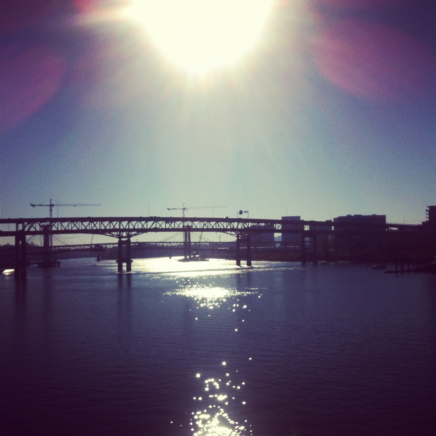
The walk is lovely, especially on a cold, crisp, but sunny November day. The leaves are mostly down and the water is cold and clear. We started in Sellwood where Umatilla meets the Springwater Trail. We walked toward Oaks Park and the Oaks Bottom Wildlife Refuge and then continued on the trail toward Ross Island. The island, the river, the wildlife, it’s just lovely.  We continued walking past OMSI and onto the Vera Katz Esplanade and then crossed over the Steel Bridge. This weird duo ran past us as we were nearing the bridge. I think I noticed them because the older of the two was wearing a non-running friendly backpack with jingly keys in it. My sister and I decided they thought we were slow because we were wearing jeans and hiking boots, but we quickly caught up to them and then passed them. Then they ran around us again. My sister laughed. She said, “Three minutes and we’ll have to pass them again.” Sure enough, we passed them again on the west side shortly before we walked back across on the Hawthorne bridge. We may not have fancy workout clothes, but we don’t mess around. We are tall and we have long legs. We walk very very fast.

As we headed back toward Sellwood, we both started to get blisters and sore joints. The number of people who use the Springwater Corridor gives me a renewed faith in humanity though. Hundreds of people braved the cold to get out in the sunshine and get some exercise. I approve. I also got to see SteveZ as he rode by us in the opposite direction. It’s always nice to see a friendly face. Last time I walked the trail by myself I saw Eric Tsai. Apparently I can’t go for a walk in Portland without seeing someone familiar. Portland is beautiful, but I can’t wait to be back in the wilderness next Sunday!

For information about the Springwater Corridor click here.

Hike 17 – Two Chiefs Trail

Two ChiefsSince we hiked in the coast range last week and majestic Mt. Hood is covered in snow, my sister suggested a Columbia Gorge hike this week. After some searching we decided on the Two Chiefs Trail hike. It is on the Washington side of the Gorge, just the slightest bit west of the Bridge of the Gods. We found it with no problems, but the road to it was too much for our trusty steed (Sid Hoffman). Mazdas are pretty low to the ground and there were car-swallowing potholes. After we bottomed-out once, we decided to just park it and walk the extra amount. The official hike is 7.8 miles with 1250 feet in elevation gain, but we did a little bit more than that because of our parking spot.

The trail used to be a road, but it has been washed out over and over and over again and now is hard to negotiate even on foot. It immediately climbs 500 feet. It was too much for my sister. We stopped numerous times to shed layers of clothing and drink water. For the first time ever I was the person not holding up our hike.

There was a lot of water on this hike, a lot. The trail was washed out in numerous places and culverts that should have diverted the water under the trail were in disrepair or malfunctioning. We did not have waterproof shoes on but we both remained dry due to some crafty navigating. At one point we used a fungus covered stick we found to balance as we crossed a log that was trying to roll out from beneath us. It all worked out. My sister at first decided that the trail was called “Swampy Gillespie” instead of Two Chiefs Trail. Then after some unpleasant discussion we decided that having a swampy gillespie sounded like a euphemism for a horrible STD. She then started calling it “Crazy Creek Trail.” Seriously, in several sections the trail is a creek bed with running water. Our dry feet are a miracle.

After winding around and climbing through tons of different beautiful scenery, we finally reached a summit. The gorge view, the field of moss covered scree,  a gorgeous waterfall at Greenleaf Creek, and Table Mountain just above you make for a pretty epic end to your uphill journey. It was 2:30 when we hit the summit and it took us over two hours to get there. After the daylight savings change we were a little worried about getting caught in the dark. We have headlamps, so we’re not totally unprepared, but it was still a concern. On the way down, the parts of the trail with thick forest were very dark. Now that it’s November we will have to make sure to be careful about time. It took us just under four hours to complete the entire hike. The trail intersects with quiet a few others, so I’m sure we’ll be back in the area again. It was beautiful.

For information about Two Chiefs Trail click here.

Hike 16 – Gales Creek Trail – Reehers Camp to Bell Camp

Gales CreekIt was so nice to be in the middle of nowhere hiking again today. Sometimes you have to “hike” in town but it’s really just not the same. After the Alameda Ridge trail last week, I did a solo walk on the Springwater Corridor. It was good exercise, but it was no hike. Hiking is different. I enjoy it so much more.

After a snowy week, a majestic Mt. Hood hike was definitely out today. I wanted something with some elevation to it, so we ended up back in Timber, Oregon, very close to where the Wolf Creek Trestle hike began. Today we did the Gales Creek Trail. It is a 12 mile trail but we only did a 3.4 mile portion (6.8 miles in and out) from Reehers Camp to Bell Camp. It has 1450 feet in elevation. However, all of that was in the last mile. It was very steep, probably the steepest thing we’ve hiked besides Hamilton Mountain. The first 2.4 miles meander around beautiful scenery. Then you cross several logging roads and basically head straight up. We were up to the challenge today. We barely stopped to rest at all.

Close to the end of the trek up, we started hearing chainsaws. Instead of assuming that some totally normal person was cutting firewood, we assumed it was a chainsaw massacre ahead and we walked with much more caution. It was a chainsaw massacre. There was blood everywhere. Just kidding, it was a family getting firewood. They waved at us. We always imagine our hikes to be much more frightening than they are.

Because of the steepness, reaching the summit was quite a feat. We were ecstatic when we did. We had already eaten our Subway in the car, so we took a couple swigs of water and headed back down. Besides the people cutting wood, we saw no one else. It was a lonely beautiful day in the Tillamook National Forest. Through the trees we could see Mt. Rainier, the vastness of the Tillamook Forest and sun-speckled fungus that covered the forest floor. Some even looked like coral. It was crazy. For my friends who ride mountain bikes, the trail is also open for that and it would be incredibly fun. Do it!

For information about Gales Creek Trail click here.