Hike 10 – Forest Park – Leif Erikson Dr – Germantown to Saltzman

mushroom“Chugga, chugga, chugga, chugga, steamboat.” This was our mantra today. I don’t know why. My sister kept saying it. I think she saw a boat when we were driving by the Willamette. It was definitely not a steamboat, but whatever. There were torrential downpours and “monsoons” in the Portland Metro area this weekend. Apparently it’s not over and tonight is supposed to be even worse. I finally broke down and bought some rain gear from Costco. It fits like a dream and it definitely got some use this weekend after the Duck game and the hike. It needs the Scaife Approved Camp Dry treatment though. I’ll be sure to do that before I wear it again.

We had intended to do the final Sunday Parkways today, but the City of Portland cancelled Sunday Parkways due to extreme weather warnings. Annoying. We figured why not hike the other half of Leif Erikson Dr. We drove into the lot at Germantown Rd. and went in until we hit where we stopped last week, Saltzman Rd. It was a 10 mile hike. Again, we went for distance since Forest Park doesn’t have a ton of elevation. In retrospect, we shouldn’t do such long hikes with rain gear. It really weighs you down and makes the hike much more rigorous. When we had about 2 miles left we had been silent for about a half hour and I said, “This is hard.” My sister agreed.

It rained hard the whole time but we stayed pretty dry in our spiffy rain gear and waterproof hiking boots. We only passed about 10 people all day. Rain does that to hiking trails. We noticed something. Every other hike that we’ve done, not in Forest Park, everybody is so friendly. We smile, say hello, talk about the trail, etc. In Forest Park no one makes eye contact, no one says hello, no one smiles, it’s really really creepy. Are people in Portland just jerks in general or is Forest Park’s reputation so bad (admittedly it’s bad) that people are afraid to be kind?

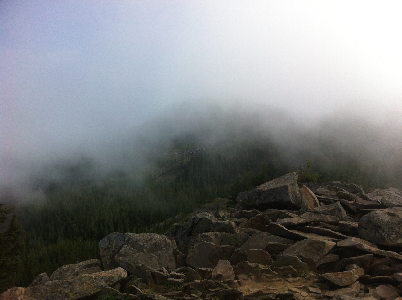
There was a lot of fog. It created an illusion that was disorienting. It was quite a lot like a dolly zoom in a horror flick. It looked like the world was zooming out while we were standing still. I was trying to explain it to my sister, but I called it a zolly doom. Then we spent a lot of time talking about what exactly a zolly doom is. I haven’t mentioned it before, but we also talk about ‘squatch a lot. We’re pretty sure they exist and at some point during the 52 hikes we’ll see one. A girl can only dream.

We headed down toward Saltzman and then turned right around and came back. There was not a lot of fan fare because the rain was pretty intense. I ate my Subway under a tree in about 3 bites. It was a pathetic lunch stop. We kept going at a steady pace and never stopped to rest. We did the 10 miles in 3 hours. That’s pretty good considering the amount of debris (pronounced da-briss) that was clogging up the trail. We like Forest Park. Eleven miles down, 69 to go to complete the All Trails Challenge.

For information about Forest Park click here.

Advertisement

Hike 9 – Forest Park – Leif Erikson Dr. – Thurman to Saltzman

forest

Originally we were going to hike Cascade Head near Lincoln City for our ninth hike. However, when the weather channel said there would be about an inch of rain, we nixed that idea. We are Oregonians, don’t get me wrong, we love a good rainstorm and we don’t mind getting out in it. We just didn’t want to be two hours from home when we were soaked to the bone. My sister has a ton of water proof stuff because of her job, but I do not. We scrambled and looked for a new hike. That is when I discovered the Forest Park All Trails Challenge. There are 80 miles of trails in Forest Park. Now we have to do all of them. You throw the word challenge at me and I’m all in.

We have hiked in Forest Park before, but not with any direction. We headed toward the Thurman Rd. gate entrance and hopped on Leif Erikson Drive. There were a lot of people, more than we are used to, lots of static stretchers blocking the parking area and making me want to ram my car into their open doors. Fun fact: in Oregon if you open your door into traffic you are 100% liable for the damage. It took every single ounce of restraint I had to keep my mouth shut. For those who know me well, I deserve an award for that.

Since Forest Park doesn’t have a lot of elevation change, around 500 feet, we decided to go for distance. We went in to Salztman Rd and back. It was 12.4 miles. I figure on another day we can go to the other end of Leif Erikson Dr and get in a nice 10 miler to help us meet the All Trails Challenge.

It turns out the people who spent a half hour static stretching, something my sister and I don’t believe in before a workout, only ran like two miles. Once we got more than three miles in we saw an occasional runner and a few mountain bikers, but for the most part we were alone. The trail was a road, so it was wide and well- maintained. It did rain, hard. We did get very very wet. There was a lot of tree cover though and the hard rain was sporadic so we didn’t mind. The trail was slightly uphill most of the way, but it wasn’t tough. We didn’t stop to rest at all. No “let me catch my breath” breaks were required. We did walk under one dry spot at about mile 5. My sister was hungry so we just plopped down mid-trail and ate our Subway. She didn’t eat breakfast before. Bad idea. While we ate only two people passed us. Rain has a tendency to thin out trails.

We kept heading upward and it seemed like we hit Salztman really fast, 6.2 miles, halfway to go.

We turned around and headed back down. There was this weird optical trick on the trail though. For most of it, no matter where you are standing, it looked like it was slightly uphill both ways. It’s the mythical road your grandparents used to walk to school (uphill both ways). It really made us laugh for some reason. You could seriously stop anywhere and look both ways and they both looked slightly uphill. We also noticed on the way down that the mile markers are every quarter mile. It’s annoying. You don’t need that much info. Sometimes not knowing is better.

My sister’s hands turned blue again and we did a tiny amount of prancercizing right as we got back to the Thurman gate. Mostly we were covered in mud to our knees. It was a beautiful day. I’m glad we hiked so far. I like longer hikes.

For information about Forest Park click here.

Hike 8 – Tom, Dick, and Harry

harryWell, we are getting tough. It’s official. We set out on this hike today because my friend and coworker, Rich, and his family did it over the summer. I saw their pics on Instagram and it looked pretty. When we looked it up, the hike seemed right up our alley. It is a 6.4 mile hike with 1600 feet of elevation gain. After last week, everything seemed easy in comparison. Rich warned me that it’s pretty much up one way and down another. It was weird though. We didn’t even feel very tired. We barely stopped at all. We hiked right up…and it was incredible.

Ever since I was a little kid going to Skibowl with my dad, I always wanted to know what was across that little bridge off of highway 26 where all the cars were always parked. Seriously, I’ve always wanted to walk across that stupid little bridge. Today my dreams came true. We bought a year-long recreation pass in Welches. We have paid each time for parking which is stupid. It will last until September 2014. There is no way we are quitting at 52. We just guarantee 52. We used a pretty gross outhouse (use the bathroom in Welches) and then walked across my dream bridge. It was totally all that I imagined.

Mt. Hood was completely socked in with fog. It was thick, whispy, amazing fog. We loved it. The trail was well maintained and obviously highly used, at least up until Mirror Lake. There was a slight incline all the way up to the lake with several switchbacks but it was pleasant. We talked most of the way up which means we weren’t totally winded. We saw a lot of people on the way back down, despite getting an early start, and figured they were just doing the short Mirror Lake portion. We finally reached what appeared to be the top, but there was no lake. It was a sea of fog. We assumed the lake was in there somewhere. We walked down some stairs to make sure and indeed we found water. I have seen a lot of pictures of mirror lake, but I had never seen it. I still haven’t, but I’m okay with that.

We headed up the trail toward Tom, Dick, and Harry Mountain. It was a thin path with a lot of rocks and roots. My sister and I are clumsy. We trip quite frequently and today was no exception. I did break my toe when I fell on the way down Hamilton. It is still purple and swollen. Sharock Bruce Hannah, Esq. bought me brand-new hiking boots because he couldn’t stand to see me hike in my tennis shoes any longer. On our way up we passed six people. That’s it. The cold weather was awesome. Everyone who passed us said it cleared up on top and majestic Mt. Hood was beautiful. We were super excited. We passed a huge pile of rocks. I decided it was Rockbiter’s lunch. Now I want to watch Neverending Story, really bad. We headed into an obvious burn area. The new life growing around the burned trees was so beautiful, circle of life and all that. The trail got steep and rocky but we could see blue sky so we knew we were close. We crested the hill and the fog had followed us. Mt. Hood was entirely obscured. I honestly don’t care. The fog and the way the wind was blowing it across the mountaintop was so amazing. We had never seen anything like it. We settled in on big rocks for our Subway and enjoyed the wildlife; some chipmunks wanted to share with us. We do not share.

The walk back down was awesome. Downhill is always awesome.  My sister noticed that her left hand was blue about halfway down the trail. We decided that it was either from her new jeans or that she was dying. We both hoped that she wasn’t dying, but you never know. It’s hours later and she’s on the couch next to me drinking a nice pinot noir, so I assume it was just the jeans. We worked on some prancercizing on the way down. We’re pretty sure it upped our fitness an incredible amount. We’re going to add it to our repertoire.

For information about Tom, Dick, and Harry click here.

Hike 7 – Hamilton Mountain

hamiltonI was joking around with my friend and coworker Kris that my sister and I had gone east, south, and west to hike and that our next hike should be north. She said, “Have you ever hiked Hamilton Mountain? It’s my absolute favorite.” So, obviously we had to go to Hamilton Mountain this week regardless of what the trail was like. I also mentioned it to another friend and coworker, Josh, who said, “That is one of my favorites.” He then said, “It took me about six hours.” He saw the look on my face and amended, “but I’m a dawdler.” I said, “Yeah, I’m a dawdler too but not for sightseeing purposes. It’s mostly because I can’t breathe.” I think he thought I was kidding. I was not.

Hamilton Mountain is on the Washington side of the Gorge. It is off of highway 14 and part of Beacon Rock State Park. We did not bring money for parking…again, but my sister had her checkbook. Thank goodness. We knew ahead of time that we were hiking 7.5 miles and that during that time we would a make 2100 foot elevation climb, but we really didn’t know what that would entail. The most elevation we had done previously was 700, so we more than doubled our best climb.

The hike was basically straight up. There are, if I remember correctly, two places in the entire hike where you are flat for a moment. My sister had no problems with the elevation climb. She slowly climbed her way at a steady pace. I did not. I hyperventilated, many times, and had to stop A LOT, but we are not quitters. If you’ve ever met my dad you will understand that we actually are incapable of quitting things. It’s in our DNA. We would have finished if it killed us, which it didn’t, luckily.

Every webpage I looked at said to do the loop counter clockwise, to hike the gorge side on the way up and the forest side on the way down. We had fully intended to do that until we met Greg and Paige. Greg, and his 8th grade daughter Paige (and their 9 year old dog Dexter) started the hike around the same time we did. We had similar paces and we kept running into them along the way. After awhile, Greg decided we needed to know each other’s names (and life stories). Something I’ve never mentioned before is how much my sister and I value silence. Ever since we were little we could sit in a room together, enjoying each other’s company, for hours without saying a word.  We’re not antisocial; we’re contemplative. When we hike we talk, but sometimes we also literally go miles saying nothing. Mostly we say, “Look at that,” when we see something beautiful. Greg was too much for us. They got out a little bit ahead and took the gorge side trail. We stealthily took the forest trail. We were free.

In retrospect, I would recommend that route to anyone. It is hard to appreciate the beauty of the gorge trail if you’re gasping for air. Go down it. You can see everything. Plus, the forest trail (It’s actually called Hardy Creek Trail) is way less steep and more meandering. We really liked it.

Despite taking the meandering trail it was still tough. I couldn’t make it to the top before eating as we planned. I actually came to a point where I couldn’t take one more step. We sat down in the shade and ate our Subway and drank all of our water in the middle of the trail. Yes, we drank all of our water before we even got to the top.

When you take the forest trail, you emerge at the top of this beautiful plateau. You can see for miles in all directions. It’s worth it just for that. Do not do this hike without seeing that view. It’s the centerpiece (we ran into Greg and Paige later and they never went to the plateau; they missed it).

After we made it to the summit (the summit is anti-climactic), we headed down the super steep gorge trail. I full on fell twice, like every part of me on the ground. I terrified my sister, especially when I slid in the dirt for several feet. Since I have a history of falling down cliffs, she was worried. I’m pretty sure I broke the big toe on my right foot; war wounds make you cooler.

I have never seen the gorge the way that I saw it today. I could see majestic Mt. Hood, Bonneville Dam, and amazing barges that took up the whole river. When you climb 2100 feet the change in plant life is pretty astounding too. It goes from wet forest ferns and mud, to dry windblown grasses. Incredible. It was worth every minute.

For information about Hamilton Mountain click here.

Hike 6 – Silver Falls

fallsTen years ago I tore my meniscus walking on flat pavement. While I was still suffering from the injury and before I even knew what I had done, I headed to Silver Falls for the first time to hike. It didn’t work out. I walked to one falls, complained a lot, and then sat in the car.

That experience was why the Silver Falls Trail of Ten Falls had to be one of our hikes. We got Subway beforehand. We learn from our mistakes. We hopped in the car and headed south. We intended to take the Woodburn exit from I5 on Labor Day weekend. Does anyone see a problem with this logic? Every human being in Oregon was at the Woodburn outlet stores doing last minute school clothes shopping. Our car travel was unpleasant. We ate our Subway as we waited to exit the freeway behind all the frantic moms and children. Some people were even parking on the interstate. Crazypants.

We finally made it to Silverton and were heading toward the trailhead when I remembered that we needed money to get into the park. We headed back to Silverton and found the only bank in the world with no ATM. Not only did it not have an ATM, but it had a sign where the ATM should be that read “Looking for an ATM?” It then had a bunch of nonsense about calling some 1-800 number. “Silverton, really, what is this 1980?” asked my sister.

Once we got into the park we hopped on the trail at the South Falls. The Trail of Ten Falls has several places that people can join the trail. This also means it has several places for dullards in high-heeled sandals and no trail etiquette to stomp five abreast in front of you at glacial pace. Labor Day weekend makes for a lot of people who think they want to hike. They don’t. They need to go home.

Once we got away from the entrances, we really had a great time. You actually walk behind several of the falls through beautiful moss-covered caverns. The height of the falls, the power of the water, it’s enough to take your breath away. There were great walls of fern, salmon berries, and lava rock that made the water take the most interesting paths. Silver Falls is beautiful.

There is a fair amount of uphill as you head from South Falls to North Falls, but I would highly recommend doing it the same way we did it. There is a canyon trail and a rim trail that make a loop. The canyon trail leads along the river, meandering up and down hills and showing you the sites. The rim trail runs along the road. It’s still pretty, but it’s no canyon trail. End with the rim trail, trust me.

When we got back to the car, we decided to drive to our parents’ house on the back roads. If you’re going to Silverton, take the back roads. The extra time is worth the view. The fields are incredible.

For information about Silver Falls click here.