Hike 16 – Gales Creek Trail – Reehers Camp to Bell Camp

Gales CreekIt was so nice to be in the middle of nowhere hiking again today. Sometimes you have to “hike” in town but it’s really just not the same. After the Alameda Ridge trail last week, I did a solo walk on the Springwater Corridor. It was good exercise, but it was no hike. Hiking is different. I enjoy it so much more.

After a snowy week, a majestic Mt. Hood hike was definitely out today. I wanted something with some elevation to it, so we ended up back in Timber, Oregon, very close to where the Wolf Creek Trestle hike began. Today we did the Gales Creek Trail. It is a 12 mile trail but we only did a 3.4 mile portion (6.8 miles in and out) from Reehers Camp to Bell Camp. It has 1450 feet in elevation. However, all of that was in the last mile. It was very steep, probably the steepest thing we’ve hiked besides Hamilton Mountain. The first 2.4 miles meander around beautiful scenery. Then you cross several logging roads and basically head straight up. We were up to the challenge today. We barely stopped to rest at all.

Close to the end of the trek up, we started hearing chainsaws. Instead of assuming that some totally normal person was cutting firewood, we assumed it was a chainsaw massacre ahead and we walked with much more caution. It was a chainsaw massacre. There was blood everywhere. Just kidding, it was a family getting firewood. They waved at us. We always imagine our hikes to be much more frightening than they are.

Because of the steepness, reaching the summit was quite a feat. We were ecstatic when we did. We had already eaten our Subway in the car, so we took a couple swigs of water and headed back down. Besides the people cutting wood, we saw no one else. It was a lonely beautiful day in the Tillamook National Forest. Through the trees we could see Mt. Rainier, the vastness of the Tillamook Forest and sun-speckled fungus that covered the forest floor. Some even looked like coral. It was crazy. For my friends who ride mountain bikes, the trail is also open for that and it would be incredibly fun. Do it!

For information about Gales Creek Trail click here.

Hike 15 – Alameda Ridge

alamedaWe knew eventually this would happen. Because my sister works for a company that has varying shifts, despite having every Sunday off for years, this Sunday she was scheduled to work. During the holidays it happens too because she gets switched to graveyard and it messes everything up. It won’t stop our hiking; it will just make us be more creative.

This week we hiked on Thursday, Halloween. I was half in costume with red hair and scary makeup and half in my workout clothes. It was a strange mix. Because we couldn’t start until I got off work, we needed somewhere urban and with lights. My sister found the Alameda Ridge stairs and it seemed perfect. Nestled between the houses along the ridge are numerous, almost hidden staircases. The loop we walked was 4.5 miles. In retrospect, it was not very challenging. What we really want to do is get our hands on a map of all the staircases and make our own route.

We enjoyed the walk. It was a beautiful night and we got to see all of the Halloween decorations and cute kiddos in costume. The mapped route started on 50th Ave at Sandy Blvd, right by the post office. We headed up our first set of stairs up to Wisteria and the adventure began. We wound around the beautiful neighborhoods taking in the sites and the crisp October air. We got lost a couple times, not really lost, just off trail, but since we were in the city we weren’t really worried like in the woods. It’s easy to find your way back to a parked car on 50th Ave regardless of where you end up.

The stairways are really cool. They’re actually really hard to spot. The directions had house addresses so you could find them. We started our hike at dusk so the walk was pretty dark. There are a lot of people in the Alameda area who go all out on Halloween. We kept a count of the people who do not understand how to use fake spiderwebs. It’s a pet peeve of ours. The final tally was something like 20 to 1. In other words we saw one house where the spiderwebs looked cool, like real spiderwebs.  We’re Halloween snobs.

We did not get Subway. It was Halloween. I had my first Burgerville burger in four months. The key to losing weight and keeping it off is not denying yourself those little pleasures. It was delicious. We went home and watched two episodes of American Horror Story. It was a wonderful walk and a wonderful Halloween.

I will probably walk by myself on Sunday while my sister works. It won’t be the same without her.

For information about the Alameda Ridge Walk click here.

Hike 14 – Bald Mountain from Lolo Pass

bald

This week’s hike was a whim. My sister and I were in the back of my parents’ Subaru riding to the Ducks game on Saturday when we realized we didn’t have a hike picked out yet. I have almost no data left on my phone for this month (I watch Netflix at the gym and it uses it up so quickly now it’s ridiculous), so I grabbed her phone and did a random search for Mt. Hood hikes. We hadn’t done anything off Lolo Pass since our first hike (Ramona Falls) so I decided that was a good start. Bald Mountain was a 6.6 mile hike with a 1400 foot elevation gain and seemed perfect for our needs this week. It was decided. In the five minutes I searched on the phone I got car sick. I cannot do anything but watch the road if I’m a passenger. Motion sickness is awful.

When we woke up on Sunday morning, it was raining. Neither of us expected that, so out came the rain gear. As we got in the car and headed east, the torrential downpour started. I even had to put the “winshell” wipers in hyperdrive for part of our commute on Highway 84. We kept saying it would lighten up as we got up higher. As it turns out, we were right. When we finally reached the Lolo Pass Trail Head, it was a light sprinkle. We ate our Subway in the car, put on our rain coats, and headed out. There was only one other car on all of Lolo Pass Rd. This is Oregon, people. If you don’t get out in the rain, you don’t get out. Buck up.

The hike had a lot of varied terrain. You start in an old burn with rhododendrons everywhere. Then you make your way into a densely packed forest and start heading up the switchbacks. There were so many mushrooms of so many varieties, it was crazy. About four years ago I went on a bike tour with a bunch of hashers. If you don’t know what hashers are, you’re probably better off (kidding). They call themselves drinkers with a running problem. I always wanted to be a hasher but I have two things holding me back: I cannot run after back surgery and I cannot drink beer because I have Celiac disease. Since they run and drink, I’m kind of out of the club. For information about Oregon hashers click here. Beware, they are fun. Anyway, on our tour Pabst, one of the hashers, (the others were O, Scratchy Hole, String Cheese, and Dancing Queen) kept making up really funny names for the birds we saw. You see, O is kind of a bird freak. He names every flying thing that is within about 10 miles and insists on pointing it out to you. Pabst decided it was all lies and he could play the same game. He started saying, “Oh look a great pileated blue tip” (which of course does not exist but sounds scientific) every time a new bird appeared. It was hilarious. Well today on the hike there were these really pretty red mushrooms. My sister decided they were called Red Death Drops, the most deadly mushrooms in the world. Even touching them meant certain death. She then explained that they were often confused with Red Yum Yums, the most delicious mushrooms in the world. This confusion had the potential to cause world-wide chaos and untold deaths. These are the types of things we talk about while we are hiking.

After about two and a half miles we reached an intersection where you could continue on the Pacific Crest Trail, take some other off-shoots including Tom Spur, or hit the Timberline Trail. Our route took us up the Timberline Trail for only  a moment. Then we turned off at the unmarked Bald Mountain Spur. Climbing this trail was the reason that you can’t hate switchbacks. It was the steepest thing we have ever climbed. It did not meander or turn. It went straight up. We had to stop and catch our breath quite frequently. When you are yearning for switchbacks, you know you’re on a steep hill.

It had been snowing on us since we hit the trail intersection. By the time we reached the summit, it was big beautiful flakes sticking on our heads and the ground. It was absolutely incredible. You are supposed to have views of Majestic Mt. Hood on the hike, but we didn’t mind the fog bank because of the amazing snowfall just for us. On the hike we only saw one other person and he was hardcore hiking on the Pacific Crest Trail. My sister said hello to him, after we sang him a song about knives, but he ignored us. He quickly disappeared from sight.

The way back to our trusty steed (Sid Hoffman) was entirely down hill. It was heavenly. We did the hike in less than three hours and headed home to buy snowshoes. Yep, we’re hiking all winter. Snow shoes are necessary. This adventure is awesome.

For information about Bald Mountain click here.

Hike 13 – Wolf Creek Trestle Hike

Posting this has been a challenge. Technology and I have had an epic battle today. I win.  Since we started this adventure, my sister and I have spent a lot of time researching using the Portland Field Hikers Guide. When I was putting in specs for a longer hike a few months ago, I found the Wolf Creek Trestle Hike. I thought it sounded pretty darn cool, but it was definitely outside of my comfort zone. I was kind of terrified to do it, but I knew I wanted to.

The hike itself is pretty remote, but it’s also in a really remote location. It doesn’t have a standard trailhead and hordes of people, it’s just a road. It’s just a road that is nestled in a labyrinth of unlabeled gravel roads that meander through the Tillamook National Forest. The directions say things like, “you will reach a five way junction, take the second road on the left.” I HATE getting lost so this was definitely a deterrent. It didn’t matter though. We made up our minds to do it and it was happening. Sometimes to truly experience beauty, you have to step outside of your comfort zone and power through the crippling fear.

We drove straight to the parking spot described by the Field Hikers Guide. I don’t know what we would have done if it didn’t work out. That forest is seriously a maze of roads. We saw no one else, so asking for directions was totally not even an option. Once we got parked we headed down the jeep track road next to the railroad tracks. The jeep track road lasts for about a mile and passes a beautiful pond. Then the road ends and you hop up onto the train tracks for the remainder of the hike. The tracks have about 15 washouts where they twist and dip and the earth beneath them disappears. In these places, well-maintained side trails lead you to safety and then back up onto the tracks.

When we hit the first tunnel we were scared. We watch a lot of horror/apocalypse movies and our minds went terrible places. Despite our head lamps it was dark. It was substantially darker for my sister because she didn’t take off her sunglasses. She was totally freaked about how dark it was and it was all in her head. I even asked her to stop and take a photo in the tunnel and she wasn’t having it. The tunnels on the trail are awesome. There are two.

We hit our first major trestle shortly after the tunnel. Of course, it was the most terrifying one. It was a straight, long drop, and there was no where to walk but the actual railroad ties holding the whole thing together. There were also some branches on the tracks. We slowly and cautiously negotiated the branches and my sister only thought about moving them on the way back. Duh. It was seriously scary. The rest of the trestles were easy-peasy in comparison. They had pathways for pedestrians. This hike is not for anyone with a fear of heights.

The total hike is 10 miles in and out. When we reached mile 5 the trail just dead-ended. There was this little bench made out of railroad ties, so we sat there and ate our Subway by the creek side. It was lovely. Throughout the entirety of the day, we saw one other person. As we were exiting the first tunnel on the way back (about two miles from our car) we saw someone coming toward us on the trail. He was wearing a bright orange vest and had a rifle over his arm. He asked if we had seen any deer. We had not. Once we told each other to have a good day and kept walking, I made some jokes about “the most dangerous game” and freaked myself out. For the rest of the hike I imagined him coming up behind us and taking me out. Stupid imagination.

We made it safely back to the car and negotiated the crazy gravel road all the way back to Timber, the closest “town” to our hike.

It was a scary hike. The tunnels and trestles really freaked us out, but we loved it. We were also a little uncomfortable with the shear remoteness of our location, but in the end it was a day beautifully spent. I highly recommend it. My niece would describe the hike as “skoopy.” Just be prepared.

For information about the Wolf Creek Trestle Hike click here.

Hike 12 – Wahkeena Falls – Multnomah Falls Loop

Wahkeena

One notable thing about any extended exercise is that it has the ability to clean the slate. As we begin each hike (or for other people run, bike ride, walk) we bring all our baggage with us. I got attacked by bees on Friday. My sister didn’t sleep well.  Work isn’t always as wonderful as it could be, the list goes on and on. As you hike, as you work, as you sweat, that all melts away. What remains is the beauty of the world around you and your own two feet. Keep moving!

Today we did the Wahkeena Falls – Multnomah Falls loop. It’s officially 4.9 miles and 1650 feet in elevation. We made it a little bit more than that by taking some side trails to see the sites. We parked at the Wahkeena Falls trailhead (which is your best bet since Multnomah Falls is insane all the time). We knew we were going to see some amazing waterfalls (10+) but we had no idea what was in store for us. Of our 12 hikes, this one was by far the most beautiful. My sister never takes pictures on our hikes and she took about twenty. Obviously the amazing sunny autumn day and the leaves changing and falling before our eyes helped, but I would bet the hike is beautiful year round.

There were a lot of people heading up the many switchbacks the first mile or so of the trail. Then it thinned out and we were pretty much alone, which we prefer. There were amazing rays of light shooting through the trees and illuminating everything. Rushing water was never far from the trail and the raw force of it was something that you simply could not take for granted.

The trail is NOT well marked. It never once says which trail is the loop or which trail actually takes you to Multnomah Falls. Oh, there are plenty of signs, but they all say random crap that was basically meaningless to us. We guessed and we guessed correctly, time after time. We figured worst case scenario we could always go back the way we came. We ate lunch on a log in a clearing with a small waterfall as our soundtrack.

When we had been climbing for a couple hours, we reached a trail intersection. There was this cool old guy sitting up there and he was talking to everyone that passed. He said, “Are you guys doing the loop?” We said yes. He said, “Multnomah Falls is that way. You’re totally done climbing. It’s beautiful. Have fun.” He was my hero at that moment as there were four trails to choose from and the maps they post along the trail are made by crackheads.

From that summit point down to Multnomah Falls is incredible. There are dripping cliffs, five waterfalls, a rushing clear river, just that part of the hike was worth every minute. Then we hit the standard Multnomah Falls trail. That part was a little bit like hell on earth. My sister kept telling me to take deep breaths. There is a big difference between what we do and moms with 5 kids under 5 who are wearing wedges up the trail and talking on their cell phones as they sip on their latte from the lodge. The Multnomah Falls trail is crazy. I don’t know why anyone hikes it when there are so many far more amazing places.

We hit the return trail, which runs parallel to the Historic Columbia River Highway, and were back to the trail head in a quick .5 miles. The hike was far more glorious than we expected and thus far it is our favorite. We have a long way to go until 52 though!

For information about the Wahkeena Falls-Multnomah Falls Loop Trail click here.

Hike 11 – Angel’s Rest

Angels

When I was 19 my friend Jake Valentine gave me my first tattoo. It was prison-style, with a safety pin, and was administered on a dirty carpet in another friend’s apartment. He used my kind-of-clean sweater as a rag because there were no clean towels available. It was an ankh with horns, because I am a Taurus and an idiot. When I was 26 I decided to have it fixed/amended. My boyfriend drew up some symbols (that I wanted) that basically meant he and me for eternity. Well, since that didn’t work out, I needed something new…again. Yesterday Roll Hardy, tattoo artist extraordinaire, got started on my phoenix. It’s insane. It also made hiking an adventure. My sister has been battling a cold all week as well. We decided short and beautiful, since it was actually sunny, was just the right combination for today.

We headed up the Columbia Gorge to Angel’s Rest. It’s 4.8 miles and 1450 feet of elevation. It’s also the only hike I ever did with the aforementioned ex. As my friends Rich and Robyn Simons said last night, it’s time to make new memories. The Portland Metro Area was incredible today. Fall is in full-bloom. The sun is out but not exactly warm. Bright leaves fall on every surface. It smells like wood-burning fires and decay (but not in a bad way, in a cycle of life sort of way). I LOVE fall. It is my absolute favorite.

Angel’s Rest is a straight up sort of hike. It wasn’t the hardest or the easiest hike we’ve ever done. It definitely has switchbacks, our favorite (no sarcasm at all).  About 90 percent of the hike is through thick, lush forest. The very top is exposed, providing glorious views of the gorge in all directions. It was a crazy busy day at Angel’s Rest. It’s a pretty busy hike anyway, but a sunny day in October? You better believe it was packed. We parked on the side of the road because both lots were full. This really rad old dude parked in front of us. His license plate was NW HIKR. He hopped out and tied on his blue hiking bandana and hit the trail like nobody’s business. We stayed with him pretty much the whole hike. He was awesome.

It truly is a beautiful hike with bubbling brooks (as my sister always calls them) and gorge views in numerous places. When you reach the top it is breathtaking. Some other people had lunch with them, like we always do, but there were a lot of jealous glances at our Subway. It was delicious, as always. The last time I hiked Angel’s Rest I remember seeing gigantic Red-Tailed Hawks circling under the cliffs. No cool birds this time. We stood at the top for about 10 minutes taking in the view and then headed back down.

It was a great day and my back only hurt a little. I wore my backpack on my front so that I wouldn’t irritate/agitate my new, beautiful artwork. My sister offered to carry it, but I didn’t want to be a total wimp. I felt a lot less lame with my constant need to stop and catch my breath on the uphills too.  My sister was so stuffed up, she needed breaks too. For once, but only because she was sick, we were on the same fitness level. Woot!

For information about Angel’s Rest click here.

Hike 10 – Forest Park – Leif Erikson Dr – Germantown to Saltzman

mushroom“Chugga, chugga, chugga, chugga, steamboat.” This was our mantra today. I don’t know why. My sister kept saying it. I think she saw a boat when we were driving by the Willamette. It was definitely not a steamboat, but whatever. There were torrential downpours and “monsoons” in the Portland Metro area this weekend. Apparently it’s not over and tonight is supposed to be even worse. I finally broke down and bought some rain gear from Costco. It fits like a dream and it definitely got some use this weekend after the Duck game and the hike. It needs the Scaife Approved Camp Dry treatment though. I’ll be sure to do that before I wear it again.

We had intended to do the final Sunday Parkways today, but the City of Portland cancelled Sunday Parkways due to extreme weather warnings. Annoying. We figured why not hike the other half of Leif Erikson Dr. We drove into the lot at Germantown Rd. and went in until we hit where we stopped last week, Saltzman Rd. It was a 10 mile hike. Again, we went for distance since Forest Park doesn’t have a ton of elevation. In retrospect, we shouldn’t do such long hikes with rain gear. It really weighs you down and makes the hike much more rigorous. When we had about 2 miles left we had been silent for about a half hour and I said, “This is hard.” My sister agreed.

It rained hard the whole time but we stayed pretty dry in our spiffy rain gear and waterproof hiking boots. We only passed about 10 people all day. Rain does that to hiking trails. We noticed something. Every other hike that we’ve done, not in Forest Park, everybody is so friendly. We smile, say hello, talk about the trail, etc. In Forest Park no one makes eye contact, no one says hello, no one smiles, it’s really really creepy. Are people in Portland just jerks in general or is Forest Park’s reputation so bad (admittedly it’s bad) that people are afraid to be kind?

There was a lot of fog. It created an illusion that was disorienting. It was quite a lot like a dolly zoom in a horror flick. It looked like the world was zooming out while we were standing still. I was trying to explain it to my sister, but I called it a zolly doom. Then we spent a lot of time talking about what exactly a zolly doom is. I haven’t mentioned it before, but we also talk about ‘squatch a lot. We’re pretty sure they exist and at some point during the 52 hikes we’ll see one. A girl can only dream.

We headed down toward Saltzman and then turned right around and came back. There was not a lot of fan fare because the rain was pretty intense. I ate my Subway under a tree in about 3 bites. It was a pathetic lunch stop. We kept going at a steady pace and never stopped to rest. We did the 10 miles in 3 hours. That’s pretty good considering the amount of debris (pronounced da-briss) that was clogging up the trail. We like Forest Park. Eleven miles down, 69 to go to complete the All Trails Challenge.

For information about Forest Park click here.

Hike 9 – Forest Park – Leif Erikson Dr. – Thurman to Saltzman

forest

Originally we were going to hike Cascade Head near Lincoln City for our ninth hike. However, when the weather channel said there would be about an inch of rain, we nixed that idea. We are Oregonians, don’t get me wrong, we love a good rainstorm and we don’t mind getting out in it. We just didn’t want to be two hours from home when we were soaked to the bone. My sister has a ton of water proof stuff because of her job, but I do not. We scrambled and looked for a new hike. That is when I discovered the Forest Park All Trails Challenge. There are 80 miles of trails in Forest Park. Now we have to do all of them. You throw the word challenge at me and I’m all in.

We have hiked in Forest Park before, but not with any direction. We headed toward the Thurman Rd. gate entrance and hopped on Leif Erikson Drive. There were a lot of people, more than we are used to, lots of static stretchers blocking the parking area and making me want to ram my car into their open doors. Fun fact: in Oregon if you open your door into traffic you are 100% liable for the damage. It took every single ounce of restraint I had to keep my mouth shut. For those who know me well, I deserve an award for that.

Since Forest Park doesn’t have a lot of elevation change, around 500 feet, we decided to go for distance. We went in to Salztman Rd and back. It was 12.4 miles. I figure on another day we can go to the other end of Leif Erikson Dr and get in a nice 10 miler to help us meet the All Trails Challenge.

It turns out the people who spent a half hour static stretching, something my sister and I don’t believe in before a workout, only ran like two miles. Once we got more than three miles in we saw an occasional runner and a few mountain bikers, but for the most part we were alone. The trail was a road, so it was wide and well- maintained. It did rain, hard. We did get very very wet. There was a lot of tree cover though and the hard rain was sporadic so we didn’t mind. The trail was slightly uphill most of the way, but it wasn’t tough. We didn’t stop to rest at all. No “let me catch my breath” breaks were required. We did walk under one dry spot at about mile 5. My sister was hungry so we just plopped down mid-trail and ate our Subway. She didn’t eat breakfast before. Bad idea. While we ate only two people passed us. Rain has a tendency to thin out trails.

We kept heading upward and it seemed like we hit Salztman really fast, 6.2 miles, halfway to go.

We turned around and headed back down. There was this weird optical trick on the trail though. For most of it, no matter where you are standing, it looked like it was slightly uphill both ways. It’s the mythical road your grandparents used to walk to school (uphill both ways). It really made us laugh for some reason. You could seriously stop anywhere and look both ways and they both looked slightly uphill. We also noticed on the way down that the mile markers are every quarter mile. It’s annoying. You don’t need that much info. Sometimes not knowing is better.

My sister’s hands turned blue again and we did a tiny amount of prancercizing right as we got back to the Thurman gate. Mostly we were covered in mud to our knees. It was a beautiful day. I’m glad we hiked so far. I like longer hikes.

For information about Forest Park click here.

Hike 8 – Tom, Dick, and Harry

harryWell, we are getting tough. It’s official. We set out on this hike today because my friend and coworker, Rich, and his family did it over the summer. I saw their pics on Instagram and it looked pretty. When we looked it up, the hike seemed right up our alley. It is a 6.4 mile hike with 1600 feet of elevation gain. After last week, everything seemed easy in comparison. Rich warned me that it’s pretty much up one way and down another. It was weird though. We didn’t even feel very tired. We barely stopped at all. We hiked right up…and it was incredible.

Ever since I was a little kid going to Skibowl with my dad, I always wanted to know what was across that little bridge off of highway 26 where all the cars were always parked. Seriously, I’ve always wanted to walk across that stupid little bridge. Today my dreams came true. We bought a year-long recreation pass in Welches. We have paid each time for parking which is stupid. It will last until September 2014. There is no way we are quitting at 52. We just guarantee 52. We used a pretty gross outhouse (use the bathroom in Welches) and then walked across my dream bridge. It was totally all that I imagined.

Mt. Hood was completely socked in with fog. It was thick, whispy, amazing fog. We loved it. The trail was well maintained and obviously highly used, at least up until Mirror Lake. There was a slight incline all the way up to the lake with several switchbacks but it was pleasant. We talked most of the way up which means we weren’t totally winded. We saw a lot of people on the way back down, despite getting an early start, and figured they were just doing the short Mirror Lake portion. We finally reached what appeared to be the top, but there was no lake. It was a sea of fog. We assumed the lake was in there somewhere. We walked down some stairs to make sure and indeed we found water. I have seen a lot of pictures of mirror lake, but I had never seen it. I still haven’t, but I’m okay with that.

We headed up the trail toward Tom, Dick, and Harry Mountain. It was a thin path with a lot of rocks and roots. My sister and I are clumsy. We trip quite frequently and today was no exception. I did break my toe when I fell on the way down Hamilton. It is still purple and swollen. Sharock Bruce Hannah, Esq. bought me brand-new hiking boots because he couldn’t stand to see me hike in my tennis shoes any longer. On our way up we passed six people. That’s it. The cold weather was awesome. Everyone who passed us said it cleared up on top and majestic Mt. Hood was beautiful. We were super excited. We passed a huge pile of rocks. I decided it was Rockbiter’s lunch. Now I want to watch Neverending Story, really bad. We headed into an obvious burn area. The new life growing around the burned trees was so beautiful, circle of life and all that. The trail got steep and rocky but we could see blue sky so we knew we were close. We crested the hill and the fog had followed us. Mt. Hood was entirely obscured. I honestly don’t care. The fog and the way the wind was blowing it across the mountaintop was so amazing. We had never seen anything like it. We settled in on big rocks for our Subway and enjoyed the wildlife; some chipmunks wanted to share with us. We do not share.

The walk back down was awesome. Downhill is always awesome.  My sister noticed that her left hand was blue about halfway down the trail. We decided that it was either from her new jeans or that she was dying. We both hoped that she wasn’t dying, but you never know. It’s hours later and she’s on the couch next to me drinking a nice pinot noir, so I assume it was just the jeans. We worked on some prancercizing on the way down. We’re pretty sure it upped our fitness an incredible amount. We’re going to add it to our repertoire.

For information about Tom, Dick, and Harry click here.

Hike 7 – Hamilton Mountain

hamiltonI was joking around with my friend and coworker Kris that my sister and I had gone east, south, and west to hike and that our next hike should be north. She said, “Have you ever hiked Hamilton Mountain? It’s my absolute favorite.” So, obviously we had to go to Hamilton Mountain this week regardless of what the trail was like. I also mentioned it to another friend and coworker, Josh, who said, “That is one of my favorites.” He then said, “It took me about six hours.” He saw the look on my face and amended, “but I’m a dawdler.” I said, “Yeah, I’m a dawdler too but not for sightseeing purposes. It’s mostly because I can’t breathe.” I think he thought I was kidding. I was not.

Hamilton Mountain is on the Washington side of the Gorge. It is off of highway 14 and part of Beacon Rock State Park. We did not bring money for parking…again, but my sister had her checkbook. Thank goodness. We knew ahead of time that we were hiking 7.5 miles and that during that time we would a make 2100 foot elevation climb, but we really didn’t know what that would entail. The most elevation we had done previously was 700, so we more than doubled our best climb.

The hike was basically straight up. There are, if I remember correctly, two places in the entire hike where you are flat for a moment. My sister had no problems with the elevation climb. She slowly climbed her way at a steady pace. I did not. I hyperventilated, many times, and had to stop A LOT, but we are not quitters. If you’ve ever met my dad you will understand that we actually are incapable of quitting things. It’s in our DNA. We would have finished if it killed us, which it didn’t, luckily.

Every webpage I looked at said to do the loop counter clockwise, to hike the gorge side on the way up and the forest side on the way down. We had fully intended to do that until we met Greg and Paige. Greg, and his 8th grade daughter Paige (and their 9 year old dog Dexter) started the hike around the same time we did. We had similar paces and we kept running into them along the way. After awhile, Greg decided we needed to know each other’s names (and life stories). Something I’ve never mentioned before is how much my sister and I value silence. Ever since we were little we could sit in a room together, enjoying each other’s company, for hours without saying a word.  We’re not antisocial; we’re contemplative. When we hike we talk, but sometimes we also literally go miles saying nothing. Mostly we say, “Look at that,” when we see something beautiful. Greg was too much for us. They got out a little bit ahead and took the gorge side trail. We stealthily took the forest trail. We were free.

In retrospect, I would recommend that route to anyone. It is hard to appreciate the beauty of the gorge trail if you’re gasping for air. Go down it. You can see everything. Plus, the forest trail (It’s actually called Hardy Creek Trail) is way less steep and more meandering. We really liked it.

Despite taking the meandering trail it was still tough. I couldn’t make it to the top before eating as we planned. I actually came to a point where I couldn’t take one more step. We sat down in the shade and ate our Subway and drank all of our water in the middle of the trail. Yes, we drank all of our water before we even got to the top.

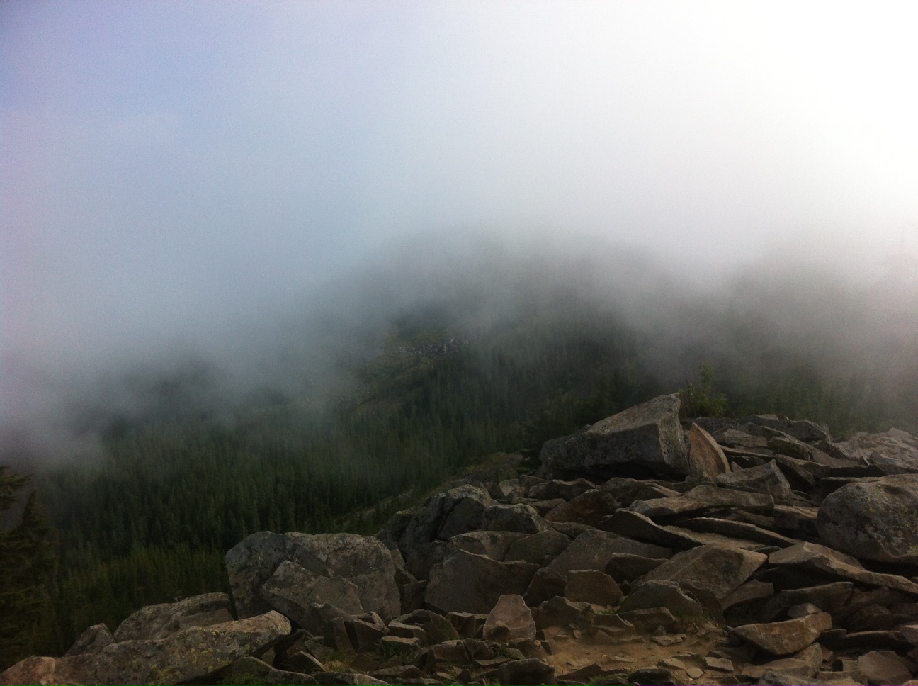
When you take the forest trail, you emerge at the top of this beautiful plateau. You can see for miles in all directions. It’s worth it just for that. Do not do this hike without seeing that view. It’s the centerpiece (we ran into Greg and Paige later and they never went to the plateau; they missed it).

After we made it to the summit (the summit is anti-climactic), we headed down the super steep gorge trail. I full on fell twice, like every part of me on the ground. I terrified my sister, especially when I slid in the dirt for several feet. Since I have a history of falling down cliffs, she was worried. I’m pretty sure I broke the big toe on my right foot; war wounds make you cooler.

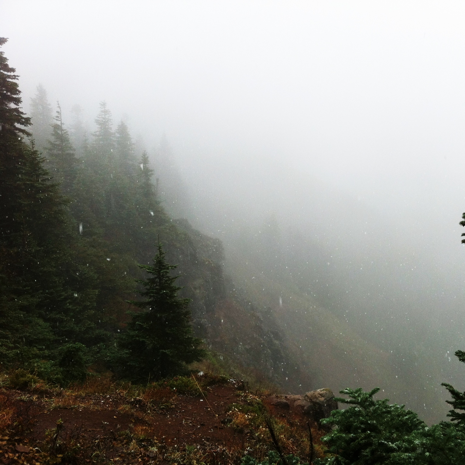
I have never seen the gorge the way that I saw it today. I could see majestic Mt. Hood, Bonneville Dam, and amazing barges that took up the whole river. When you climb 2100 feet the change in plant life is pretty astounding too. It goes from wet forest ferns and mud, to dry windblown grasses. Incredible. It was worth every minute.

For information about Hamilton Mountain click here.